ap human Flashcards
Terms : Hide Images [1]
| 14805131517 | Peters Projection |  | 0 | |
| 14805138984 | Mercator Projection |  | 1 | |
| 14805146372 | conic projection |  | 2 | |
| 14805154773 | thematic map |  | 3 | |
| 14805161570 | reference map |  | 4 | |
| 14805165119 | Dot Map |  | 5 | |
| 14805169740 | Robinson Projection |  | 6 | |
| 14805174511 | cartogram | 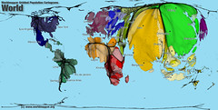 | 7 | |
| 14805179068 | Chloropleth Map |  | 8 | |
| 14810073966 | vgi | volunteered geographic information | 9 | |
| 14810073967 | Mashup | a map that overlays data from one source on top of a map provided by a mapping service | 10 | |
| 14810082970 | ratio, graphic, and written | what three ways are map scales presented | 11 | |
| 14810087641 | ratio | the numerical ratio between distances on the map and and earth's surface | 12 | |
| 14810096688 | Written map scale | describes the relationship between map and Earth distances in words | 13 | |
| 14810098961 | graphic map scale | consists of a bar line marked to show the distance on earths surface |  | 14 |
| 14810122908 | shape, distance, relative size, direction | Four types of distortion | 15 | |
| 14810126614 | Satellites, Tracking stations, a receiver | What three elements does the GPS in the US include? | 16 | |
| 14810126615 | Geotagging | identification and storage of a piece of information by its precise latitude and longitude coordinates | 17 | |
| 14810130402 | GIScience | The development and analysis of data about Earth acquired through satellite and other electronic information technologies | 18 | |
| 14810138978 | geographic grid | a system of imaginary arcs drawn in a grid pattern on Earth's surface |  | 19 |
| 14810153133 | Isoline Map |  | 20 | |
| 14810157876 | graduated symbol map |  | 21 | |
| 14810165128 | location, region, place, movement, and human-environment interaction | five themes of geography | 22 | |
| 14810170525 | uniform region | formal region | 23 | |
| 14810183615 | vernacular region | perceptual region | 24 | |
| 14810186807 | functional region | nodal region | 25 | |
| 14810193207 | Human Environment Interaction | the study of the interrelationship between people and their physical environment | 26 | |
| 14810280348 | tracking station | monitors satellites | 27 | |
| 14810283124 | receiver | locates up to four satellites, figures distance to each, and pinpoints its own location | 28 | |
| 14810726015 | Cartographic Scale | refers to the way the map communicates the ratio of its size to the size of what it represents | 29 | |
| 14810726016 | Geographic Scale | scale of analysis | 30 | |
| 14810802589 | Geography | study of the earth's surface | 31 | |
| 14810802590 | Human Geography | The study of where and why human activities are located where they are | 32 |