
Terms : Hide Images
| 4798431292 | Map Scale | distance on a map relative to the distance on Earth |  | 0 |
| 4798432610 | Large Scale Maps | show small areas in greater detail |  | 1 |
| 4798434099 | Small Scale Maps | Show large areas is less detail |  | 2 |
| 4798440679 | Reference Maps | show locations of places as well as human and natural geographic features. |  | 3 |
| 4798795769 | Physical Maps | highlight naturally occurring features |  | 4 |
| 4798796469 | Political Maps | highlight man-made features |  | 5 |
| 4798797209 | Thematic Maps | show one theme |  | 6 |
| 4798797564 | Chloropeth Maps | uses shading to show different levels of data |  | 7 |
| 4798803501 | Dot/Pin Dot Maps | each dot represents a number of occurrences -the closer the dots are together, the higher the occurrence |  | 8 |
| 4798829380 | Graduated Symbol Maps | uses a symbol to show frequency or intensity of variable |  | 9 |
| 4798829973 | Isoline Maps | connects points of equal value to make lines on a map |  | 10 |
| 4798829974 | Cartograms | show size using data other than area |  | 11 |
| 4798830536 | Flow Line Maps | shows movement with arrows of different size |  | 12 |
| 4798830537 | Statistical Maps | Thematic maps that show different levels of variation |  | 13 |
| 4798831799 | Mental/perceptual Maps | Images of places we form based on our experiences and perceptions What would your mental map be of: -Austin -Buddhism -Mars | 14 | |
| 4798891320 | Equal Area Maps | a map projection in which quadrilaterals formed by meridians and parallels have an area on the map proportional to their area on the globe |  | 15 |
| 4798892532 | Conformal Maps | a map that preserves the size of local angles in the representation; also called biholomorphic map |  | 16 |
| 4798893452 | Time Zone Maps | A map that shows time zones | 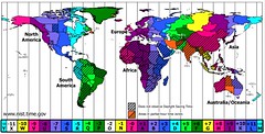 | 17 |
| 4798920185 | Lines of Latitude/parallels | measure north-south position between the poles. |  | 18 |
| 4798920858 | Lines of Longitude/meridians | run between the North and South Poles. They measure east-west position |  | 19 |
| 4798921391 | North Pole/South Pole | either of the two locations on the surface of the earth (or of a celestial object) that are the northern and southern ends of the axis of rotation. |  | 20 |
| 4798922150 | Tropic of Cancer/Tropic of Capricorn | the parallel of latitude 23°26ʹ north tropic of Cancer or south tropic of Capricorn of the equator. ASTRONOMY each of two corresponding circles on the celestial sphere where the sun appears to turn after reaching its greatest declination, marking the northern and southern limits of the ecliptic. the region between the tropics of Cancer and Capricorn. |  | 21 |
| 4798928190 | Arctic Circle | an imaginary line drawn parallel to the equator, at 23°28prime; S of the North Pole: between the North Frigid Zone and the North Temperate Zone. |  | 22 |
| 4798928692 | Antarctic Circle | an imaginary line drawn parallel to the equator, at 23° 28prime; N of the South Pole: between the South Frigid Zone and the South Temperate Zone. |  | 23 |
| 4798929560 | Equator | an imaginary line drawn around the earth equally distant from both poles, dividing the earth into northern and southern hemispheres and constituting the parallel of latitude 0°. |  | 24 |
| 4798929850 | Prime Meridian | the meridian running through Greenwich, England, from which longitude east and west is reckoned. |  | 25 |
| 4798933726 | International Date Line | an imaginary line that goes north and south through the Pacific Ocean, one day is on the east side of the line and the following day is on the west side. |  | 26 |
| 4798935108 | Map Projections | Put Earth's 3 dimensional shape onto a two-dimensional surface. All flat maps have some distortion in their representation of distance, shape, area, or direction. |  | 27 |
| 4798939044 | Distortion | Every flat map has this. They result from making A two dimensional representation of a 3 dimensional sphere. In these, the shape, size, distance, and direction is slightly wrong. |  | 28 |
| 4798945284 | Cylindrical/Mercator Projection | The globe is projected onto a cylinder of paper which is then flattened out. In this type of map, lines of latitude and longitude cross at 90 degree angles, and true compass directions are kept intact, but areas are distorted. for example, polar areas look much larger than they really are. these maps are useful for nautical navigation. |  | 29 |
| 4798949761 | Conic Projection | the globe is projected onto a cone which is flattened out.it is shaped kind of like a u. In this type of map, longitude lines are straight but latitude lines are curved. These are used for national or regional maps of mid-latitude areas. The shape in these maps are distorted but the size is shown correctly |  | 30 |
| 4798951162 | Plane/polar/azimuthal Projection | the details of the globe are projected onto a flat surface. These types of maps are accurate at the point the projection touches the map, but they have lots of distortion towards the edges. These are mostly used for circle routes, because the circle routes appear as straight lines |  | 31 |
| 4798951532 | Peters Projection | Like a Mercator map, this type of map also has latitude and longitude lines meeting at right angles. But the landmasses are more distorted than those on a Mercator map.in fact, the landmasses are so distorted, that this map is known as a politically incorrect map. | 32 | |
| 4819770448 | Location | Absolute Location: exact location on the Earth using coordinate points. Relative Location: The location of a place by comparing it to another -Cardinal location -distance -time -landmarks | 33 | |
| 4819790057 | Place | The human and physical characteristics you see. Physical -climate -vegetation -wildlife -topography Human -agriculture -architecture -religion -economics | 34 | |
| 4819804109 | Region | Formal/Uniform Region: an area defined by a limited number of related characteristics Functional/Nodal Region: areas created by movement around a central hub or node. *must have movement Perceptual/Vernacular Region: how people perceive a region -exist in someone's mind -based on how individuals perceive a region -boundaries and characteristics are different based on an individual's beliefs | 35 | |
| 4819856829 | Wilbur Zelinsky | A cultural geographer that used names of people and businesses in the phone book to map perceptual regions of the USA | 36 | |
| 4819892974 | Human-Environment Interaction | How people relate to the physical world -depend -adapt -modify | 37 | |
| 4819897631 | Movement | How people, goods, and ideas move | 38 |